Dogface Home Defense: Security
So you pulled out the terms and you pulled out the books. You’re stumped and stuck at what to do. First thing is first, you need to focus on security.
So you got your house, but you don’t know every corner to it. Worse yet, you don’t even know the surroundings on the outside of the house AKA the neighborhood.
You need to get some terrain analysis done. And this is where I can help.
When conducting terrain analysis, remember the key term OCOKA
Let’s examine each word in OCOKA
Observation and Fields of Fire
Observation - The ability to see over a particular area to acquire targets. Entirely terrain dependent. The best observations are made from the highest points in areas.
Fields of Fire - The area a weapon can cover effectively from a given point
The main difference between the two terms is the fact that you may be able to see a wider POV with just your eyes, but once you look through a scope, the view will be more limited both near and far sided.
The evaluation of this allows you to
Identify potential engagement areas
Identify defensible terrain and weapons system positions
Identify where maneuvering forces are most vulnerable to to observation and fires
Cover and Concealment
Cover - The protection from the effects of weapons fires.
Concealment - The protection from observation, either from the air or ground or both.
“Remember that cover can be used to protect a force from the effects of direct and indirect fires. Also it can, in some cases, be used to protect a force from observation. If this is the case, then the object providing cover is also providing concealment. But cover and concealment do not always equate.”
“If an attacking force can move forward under concealment, the chances of achieving surprise increase. Concealed and covered approach routes are important to reconnaissance units, dismounted infantry, and insurgent or terrorist forces.”
“Defending forces seek to defend in an area which offers both concealment and cover to themselves but which does not provide covered approaches for the threat”
Obstacles
Any natural or manmade terrain feature that stops, impedes, slows, or diverts movement.
Key or Decisive Terrain
Some terrain feature (natural or manmade) which, if controlled, will give a marked advantage to whoever controls it.
Often selected for use as battle positions or objectives
Key or decisive terrain must be controlled, not necessarily occupied. It may be controlled by either fires or maneuver.
Avenues of Approach
An air or ground route of an attacking force of a given size leading to its objective or to key terrain its path
Terrain Analysis is also dependent on METT-TC. This method is used to help remember and prioritize what to analyze during the planning phase of an operation.
Mission
What is my task and purpose for this operation?
What is the intent?
What are the specified tasks for the operation?
What are the implied tasks for the operation?
What are the essential tasks for the operation?
Enemy
What types of enemy units is the person up against?
Where are these units?
What is the enemy doing?
How strong is he?
What kind of equipment does he have?
What are his capabilities and weaknesses?
Where is he vulnerable?
Where are his kill zones and fire sacks?
What are the enemy’s intentions, doctrinal objectives, and most probable course of actions?
What can he do in response to friendly actions?
Troops
What is the present condition of the person(s), vehicle(s), and equipment?
What is the supply status of ammunition, fuel, and other necessary items?
What is the state of training?
What is the state of morale?
How much sleep have the person(s) had?
How much sleep can they get before and during the operation?
Does the person(s) need any additional equipment to support or accomplish its mission?
What attachments (help from other individuals) does the person(s) have (or require) to accomplish its mission?
How many Observation Posts (mounted/dismounted) can be manned with the available assets?
How big a frontage can be covered with the available assets?
Terrain
Use the factors of OCOKA
Time
How much time is available to plan and conduct reconnaissance?
How much time is available for rearming, refueling, and resupply?
How long will it take the person(s) to move to planned OPs, to the line of departure (LD), and/or to the objective?
Is there enough time for rehearsals?
How much time is available to the enemy for the activities listed in the previous items?
How does the potential enemy timeline for planning and preparation compare with that developed for friendly forces?
Civilian Considerations
What are the applicable rules of engagement (ROE) and/or rules of interaction (ROI)?
What procedures and guidelines will the platoon use in dealing with refugees, prisoners, and other civilians?
Will the person(s) be working with civilian organizations, such as governmental agencies, private groups, or the media?
Will the person(s) be tasked to conduct stability operations (such as peace operations or noncombatant evacuation) or support operations (such as humanitarian or environmental assistance)?
A lot of these factors from both OCOKA and METT-TC are mainly for military use, but they can be rewritten and reused to suit whatever the mission the person has. The terms are very broad and able to be worked around.
Let’s start with a picture of a house in a neighborhood.

This is only an example.
I would hope no one ever lives somewhere like this.
Observation/Fields of Fire. Urbanized terrain is characterized by restrictive O/FoF. Most of the time, you’re going to have a really bad view of everything and anything and nothing can be really done about it. Ranges will also be affected. Take every possible viewpoint and create sectors of fire for each viewpoint. Simply creating range cards for every viewpoint can be extremely helpful. Remember to have overlapping sectors so no space is left untouched. Don’t let the blind spots be your demise. Always write down your limits of observation when confronted with blind spots.
Cover and Concealment. Cover provides a physical barrier between you and the enemy, giving some protection against fires. Concealment relies on camouflage to hide your location so that the enemy can’t hit what they can’t see. Cover can be concealed i.e.. bunker or basement. But concealment itself doesn’t provide cover from hostile attacks. Cover can be everywhere in an urban environment, but pure concealment - not so much. Remember that cover is everywhere in an urban environment, but not so much with concealment.
Obstacles. Can be defined as anything that restricts movement. This can be for people or vehicles. Examples include roadblocks and barricades. Be on the lookout for any space that can be utilized as an obstacle by the enemy. Look for chokepoints - locations that restrict travel from many different routes down to just one path. These can be used as ambushes from the enemy. It can also be used on the defendant’s side, such as blocking every other direction of travel to just one lane leading to the house. Just make sure it doesn’t block your own paths of travel in case of an emergency
Key Terrain can be defined as an identifiable characteristic whose seizure or retention affords a marked advantage to either combatant. These can include public buildings, major intersections, manhole covers, security cameras, or anything that can be found with the allotted time allowed. Remember that you must also have control of decisive terrain which is a must have in order for an engagement to be successful on the defendant’s part. An example would be the house you are defending yourself. Losing this house will mean a mission loss. Keep in mind the high ground as well as the enemy will use buildings that look over your home as a vantage point. Also keep in mind public utilities and the affect that it will have on your home if it is damaged or lost.
Avenues of Approach - Look for major roads. Look for passages for travel How quickly can the enemy reach you? Keep in mind bus stops or even what routes they can take and how they’ll take them. Also remember your own avenues of approach. How long will it take to escape in the case of an emergency?
Keep in mind that weather is also a limiting factor that can quickly change every aspect of OCOKA. It can create advantages and disadvantages. Visibility will be strained.
Need help on creating a range card? I got you. Here is a video for further explanation.
" A range card is a sketch of the assigned sector that a direct fire weapon system is intended to cover. A range card aids in planning and controlling fires and aids the crews and squad gunners in acquiring targets during limited visibility. It is also an aid for replacement personnel or platoons or squads to move into the position and orient on their sector. The individual soldier or gunner should make the range card so that he becomes more familiar with the terrain in his sector. He should continually assess the sector and, if necessary, update his range card. The range card is always being updated. "
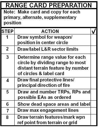
There are several goals that a Range Card seeks to achieve:
identifies key terrain, sectors of fire, MELs, Enemy AA, natural/man made obstacles, 'Dead Space'
allows several adjoining Range Cards to create a Sector (Platoon Range Card)
permits ANY replacing unit/Soldier to quickly conduct (RIP - Relief In Place)
uses a standard form for ease of use
allows for precise targeting points (distance, direction, T&E measurements etc.)
aids in targeting known points during limited visibility

Marginal Information
Includes:
Unit information (Fire TM/SQD; PLT etc.)
Magnetic North (to help orient the Soldier)

Sector Sketch Section (terrain/objects)
This field is reserved for the Soldier's topographical rendition of the terrain, its features and other targets/reference points
***Think of how the Enemy will use the terrain to their advantage***

Terrain
key terrain (hills; wood line; large tree; ENY AAs etc.)


'Dead space' (masking terrain like depressions or ground behind hills/objects)


natural obstacles (rocks, rivers, thick vegetation etc.)
Man Made Objects
defensive/offensive emplacements (wire obstacles; mines, Dragoon's Teeth etc.)
structures (houses, farms, antennas etc.)

Sector Sketch Section (military symbols)
Range Card Symbol

Shoot an azimuth/distance from a known point to your position an label it with a line and "V" tic marks
Each Range Card should show what type of weapon system is houses (at the center of the dot)
MG, AT, AR etc.
other military related symbol as appropriate


Data Section 1

Here's where it gets a little tricky...
Sector of fires
Primary (solid 'V' lines)
Secondary/Alternate (dash marker 'V' lines)


"Dead' space is marked only for FPLs by not blackening the line to the approximate length of space
Your PDF (Primary Direction of Fire) is always laid on your most important target coverage (#1)
Your FPL (Final Protective Line is your right OR left limit AND your grazing fire
Grazing fire is 1 meter off the ground to prevent Enemy Soldiers from flanking you while they low crawl
***Range Cards use either a PDF OR a FPL but never both***


Use the remarks section to describe where the position lies
You must ALWAYS have No.1 and 2 as a right and left limit (even if only marked by a FPL)
Your Range Card MUST use a PDF or FPL
All other Numbers must be targets and/or TRPs (Target Reference Points)
Data Section 2
A Range Card must accurately describe the surrounding terrain to aid in target acquisition
Each of the 9 circles represent a set distance that the user can choose. To decide on what distance each circle should be, perform the following:
identify the MEL (Maximum Engagement Line) of your FURTHEST weapon
-or-
identify the FURTHEST possible engagement distance based on terrain
For example:
If your MG team can effectively reach out to targets at 900 meters, then each 'ring' would measure 100 meters
-or-
If your MG could reach out to 900 meters but is masked by a ridge line at 450 meters, then each ring would be 50 meters
Once you've identified your MELs and set your distance scale then you must represent the terrain
draw any and all terrain features (elevation/depression etc.)
represent any 'Dead space'
illustrate natural/man made obstacles
Target description

Use "L" or "R" to describe which side your target lays on
Describe the distance in meters
Have a target 'flow' from one side of your sector to the other side to increase target recognition
Express the target elevation in meters (important also for indirect fire)
Range your target in meters
If you need to use special ammunition types, mark down which ones (HE/AP/HEDP etc.)
Describe your target (PDF/FPL; large tree; intersection; shack; vehicle etc.)
Use the 'Remarks' section for any useful instruction/comments etc.
SQD/PLT Sector Sketch

SQD

PLT
When several Range Cards are tied in together, they form a Sector Sketch
A Sector Sketch is usually a SQD/PLT sized area. Sometimes a COY sketch may be made
Steps for Sector Sketches


Remember. No written plan will ever work. Adapt and overcome.